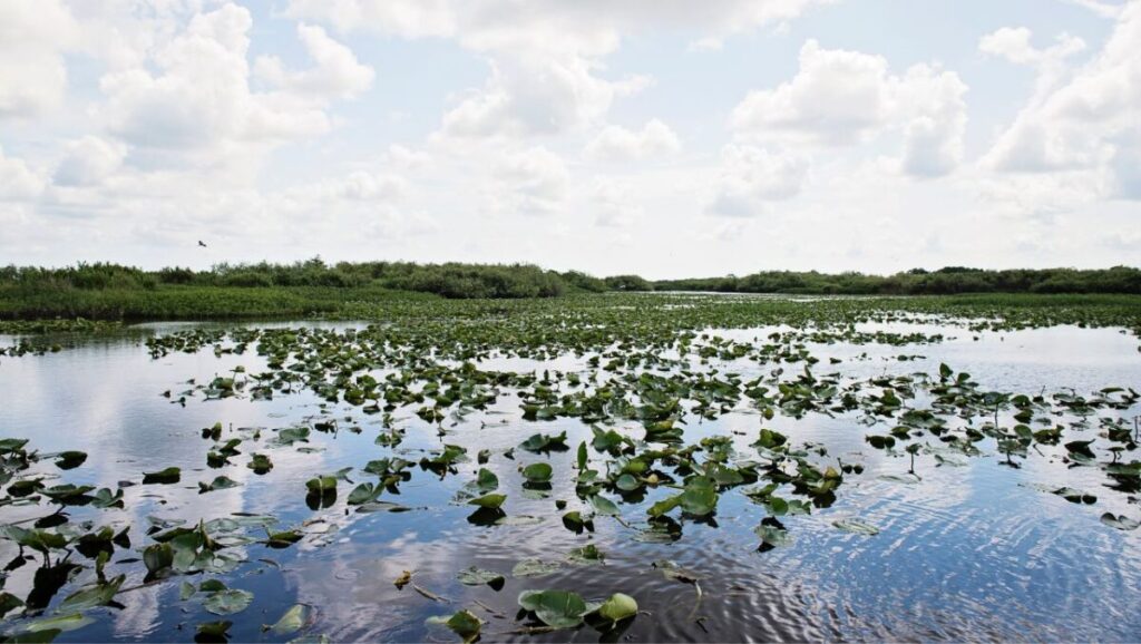
Water shapes every acre AgReserves touches. It moves through our ranches and farms, pools quietly under our timberlands, and rises and falls with seasons that have guided nearly a century of land stewardship. To us, these wetlands aren’t obstacles or afterthoughts; they are living systems that support wildlife, improve water quality, recharge aquifers, and keep our land productive over the long term.
Together, our Geographic Information Systems (GIS) and Land Management teams turn that understanding into daily practice, combining data, on‑the‑ground experience, and close coordination with regulators to manage wetlands wisely.
GIS Layers, Imagery, and Live Operations
If stewardship starts with understanding, GIS is the tool that delivers it. At Deseret Cattle & Timber in the Florida Panhandle, GIS Analyst Brice Lucas and his team combine the best available data into a single operational map that shows where wetlands occur, where wet soils are likely, and how those conditions should guide field work. That map integrates multiple data sources, including the National Wetlands Inventory, NRCS hydric soil data, state land‑cover classifications, and historical delineations from acquired properties.
It’s further refined with multispectral/infrared imagery from the National Agriculture Imagery Program, which helps verify moisture levels and vegetation patterns across the landscape. “It’s just one indicator. By itself it doesn’t classify a wetland,” Lucas explains, “but it helps us verify what the soil and wetland layers are already telling us.”
GIS goes beyond planning; it provides real‑time awareness. Position and activity reports from machines come every few seconds, allowing operators to see wetland boundaries and buffers directly in the cab while supervisors monitor crews and adjust as needed. When machines approach restricted areas, the system highlights it, reducing surprises and minimizing delays.
The result is a clearer picture of the land and smarter decisions in the field.
Balancing Work and Wetlands
Good maps matter only if they lead to good choices. Land Management Director Kent Jorgensen describes his role as helping “operations succeed – environmentally, regulatorily, and operationally. We solve problems so operations can run smoothly.”
Wetlands influence decisions large and small: where to place a new stock pond for cattle, whether an area should remain native habitat or be transitioned to pasture, or when an activity aimed at managing forests is compatible in a transitional zone. The same landscape may be off‑limits for one activity but perfectly acceptable for another. GIS clarifies those choices on a map the crew can carry.
That clarity extends to fertilizer and nutrient management. In buffer zones around wetlands, teams follow strict application setbacks; equipment maps make those boundaries unmistakable.
Working Within the Rules
Wetlands are among the most regulated parts of the landscape. Federal definitions, such as interpretations of “waters of the United States,” continue to evolve, and each state applies those rules differently. For AgReserves, this means staying current and collaborating early. When projects require review, land managers bring agencies into the conversation upfront, using clear GIS maps to show intent, boundaries, and safeguards, saving time later.
That approach extends beyond compliance. AgReserves invests in restoration and mitigation projects that improve regional water outcomes while creating new habitats. At Deseret Cattle & Citrus in Central Florida, projects such as the Eastpoint and Jug Island reservoirs were designed to filter water and improve its quality. During rain events, runoff is directed into a series of created wetlands where water slows and settles. Over several weeks, sediment drops out and nutrients decline, producing water that leaves the ranch cleaner than when it entered.
Projects such as these – once certified – can generate mitigation credits that provide future operational flexibility. It’s stewardship that also makes business sense.
When Care Looks Like Restraint
Crews on the ground see opportunities everywhere: a low spot that would make a handy stock pond, a stretch of ground that might be converted to pasture. But not all opportunities are wise, or legal.
Those tradeoffs are addressed openly in meetings that bring operations, land management, and GIS together. The outcome is rarely no, but it’s often a smarter yes: a shifted location, a different method, or a realistic timeline that avoids wet seasons.
In California, for example, Jorgensen says AgReserves has worked with state agencies to address riverbank erosion the right way – in the open, with long‑term fixes – not by “dumping rock at night,” as a frustrated neighbor once suggested.
Water Stewardship at Scale
Water challenges look different in different places. In California, where groundwater availability is the defining issue, Jorgensen says Todd Turley, a land manager at South Valley Farms, is doing excellent work collaborating with multiple water districts to find long-term solutions before state curtailments reduce available water by as much as half.
At AgriNorthwest, in the Columbia River Basin, improved irrigation efficiency is opening up “extra” water that – within regulatory frameworks – may be redirected to other acres. “That team has been very creative in unlocking future water use,” says Jorgensen.
In Chile, a nearly 20‑mile pipeline crossing rugged terrain and multiple counties is close to completion, designed to move water where it’s needed. Jorgensen says, “It’s taken years of work, regulatory and construction, but it will solve long-term shortages.”
Technology With a Human Touch
Satellite imagery, hydric soil layers, live machine telemetry, geofences, and webhooks. We use it all, and we’ll use more tomorrow. But none of that technology replaces the people who read the land and make the calls, the managers who walk boundaries after a storm, the operators who slow down near a cypress dome because they know what’s under their tires, the analysts who refine a map so it’s unmissable in a cab at dawn.
“Good days,” Lucas says, “are when the information is being distributed, and the operators are able to access it and use it to make good decisions throughout the day. When that whole process is complete, that makes for a good day in GIS.”
Looking Ahead
On World Wetlands Day, we recognize that safeguarding wetlands is both an ecological commitment and a sound business strategy. GIS makes our choices clearer, and AgReserves will keep investing in the tools that help us see. And we’ll keep telling the story because caring for land and water isn’t just how we operate; it’s who we are.